Hi together,
since I upgraded from 1.4.0 to 1.6.1, the GPS Noise-Filtering seems to be way to aggressive. Especially when driving by train.
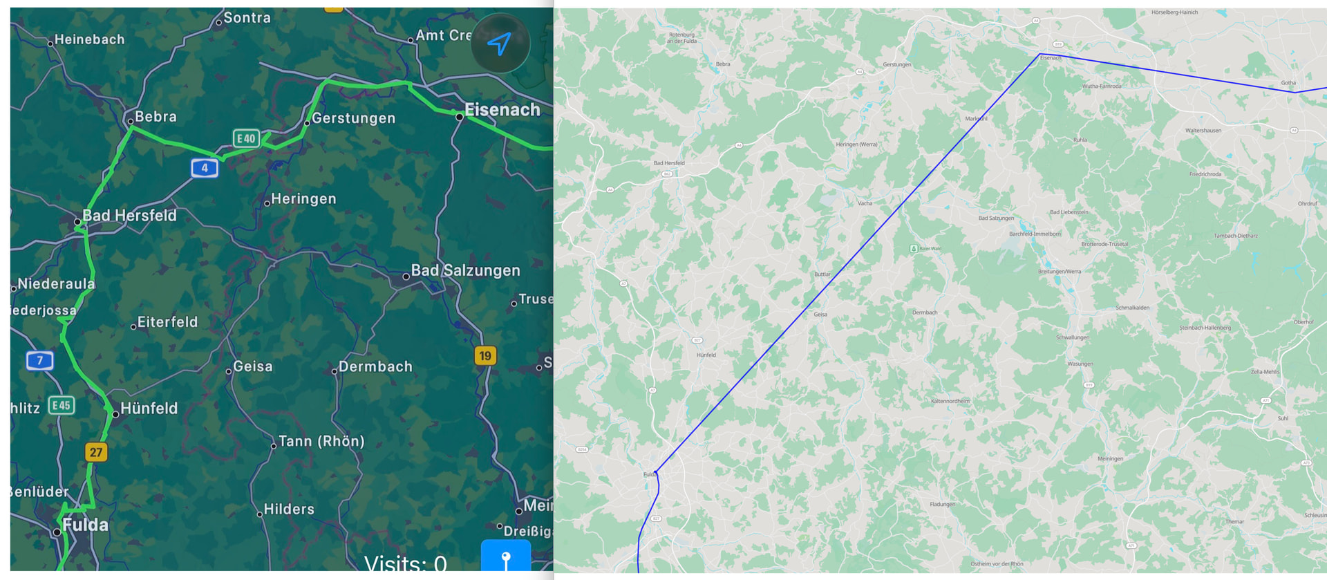
Here’s the difference between the dawarich-iOS-App (without filtering) and the dawarich-web-app (with filtering)
(left: unfiltered iOS-APp, right: dawarich-webapp-instance)
All the Data between Fulda and Eisenach got deleted.
According to the PR Detect and flag GPS outlier points (speed-based) by mormubis · Pull Request #2402 · Freika/dawarich · GitHub , there should be some settings regarding the data quality, but i couldn’t find the settings in my instance.
Does somebody know how to deal with this new feature?
btw: when i export the points into a gpx-file with dawarich-webapp, the intermediate points are still available (which is good), but not visible on the map
Best regards,
wachschaf
Here’s a screenshot of the settings, where presumably the data-quality-toggle should be located:
Any idea how to tweak the filtering-issue?
i’ve read the dawarich/CONTRIBUTING.md at master · Freika/dawarich · GitHub and decided to create a bug report:
opened 07:24AM - 11 Apr 26 UTC
**BEFORE OPENING AN ISSUE, MAKE SURE YOU READ THIS: https://github.com/Freika/da… warich/issues/1382**
**OS & Hardware**
Docker on Debian Trixie
**Version**
1.6.1
**Describe the bug**
since I upgraded from 1.4.0 to 1.6.1, the GPS Noise-Filtering seems to be way to aggressive. Especially when driving by **train**.
Here’s the difference between the dawarich-iOS-App (without filtering) and the dawarich-web-app (with filtering)
<img width="2144" height="937" alt="Image" src="https://github.com/user-attachments/assets/8d5939ff-8adc-45a3-af4c-a929de5f4cf8" />
(left: unfiltered iOS-APP, right: dawarich-webapp-instance)
All the Data between Fulda and Eisenach got deleted.
According to the PR [Detect and flag GPS outlier points (speed-based) by mormubis · Pull Request #2402 · Freika/dawarich · GitHub](https://github.com/Freika/dawarich/pull/2402) , there should be some settings regarding the data quality, but i couldn’t find the settings in my instance:
<img width="1549" height="824" alt="Image" src="https://github.com/user-attachments/assets/188eb62d-6084-419f-bf9e-5e66d175dda4" />
btw: when i export the points into a gpx-file with dawarich-webapp, the intermediate points are still available (which is good), but not visible on the map
**To Reproduce**
Steps to reproduce the behavior:
Here's the GPX-Trace to reproduce the issue:
[export_from_2026-04-06_to_2026-04-06-2.gpx.zip](https://github.com/user-attachments/files/26644222/export_from_2026-04-06_to_2026-04-06-2.gpx.zip)
Freika
April 23, 2026, 4:23pm
4
Thanks! As I responded in the issue, I’ll add settings to tweak this feature in the next release