Hello,
I have been using Dawarich for a couple weeks, importing my old Google history and linking with my immich pictures.
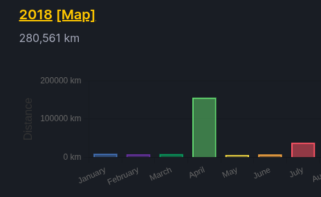
Everything looks ok, but I have strange stats for 2018.
I am pretty sure it comes from a set of pictures that was shared with me at the time, I see those pictures on the 0/0 point on the map, but I cannot delete them through the Ruby console: it does not find them. [1] pry(main)> points = Point.where(latitude: 0, longitude: 0) Point Load (267.6ms) SELECT “points”.* FROM “points” WHERE “points”.“latitude” = $1 AND “points”.“longitude” = $2 /* loading for pp / LIMIT $3 [[“latitude”, “[FILTERED]”], [“longitude”, “[FILTERED]”], [“LIMIT”, 11]] => [] [2] pry(main)> points.size Point Count (311.8ms) SELECT COUNT() FROM “points” WHERE “points”.“latitude” = $1 AND “points”.“longitude” = $2 [[“latitude”, “[FILTERED]”], [“longitude”, “[FILTERED]”]] => 0
Is there anything else I can do?
(I actually would like to register a trip for that period, but it’s also polluted by mislocated points)
Also, you can confirm your suggestion directly on the map: just select timeframe to include whole April of 2018, enable the Points layer and zoom the map out. The map also have selection tool which allows you to select an area and points inside it and bulk-delete them all.
Hi,
Thanks for the response.
I didn’t get the map search before your hint.
Thanks to it, I could see that no point was linked to my pictures on 0,0: the issue was from a small set of points located at home while I was travelling abroad leading to long back & forth trips.
Issue solved!
This was useful to me, as a new user; I managed to clean up the spurious points from my iPhone, created (I believe) when indoors.
However, the spurious points I removed from the server aren’t removed on the iPhone app, and I can see no way to (also) remove those.
So the state of the server doesn’t appear to be reflected on the phone - at least not yet; can I expect this to happen after a while? Or are points stored on the phone ‘forever’, even after uploading?